Beyond the Destination Tours

Indian Lands Journey Guide

Indian Lands

A culturally attentive Phoenix loop through northern Arizona and Four Corners country, connecting mesa and canyon landscapes, ancestral places, living communities, trading-route history, archaeology, and the high-desert roads between them.

This journey crosses ancestral and contemporary Indigenous homelands and asks for patience, respect, and attention to local rules. The places along the route are not simply historic sites: many remain connected to living Pueblo and Diné communities, family histories, stewardship, and ongoing cultural meaning.

Use this guide to see whether a 12-day loop of approximately 1,325 miles fits the way you like to travel. The pace leaves room for interpretation, short walks, changing road conditions, Tribal and park access requirements, photography rules, and time to experience places without turning them into a checklist.

Find the Journey That Fits You
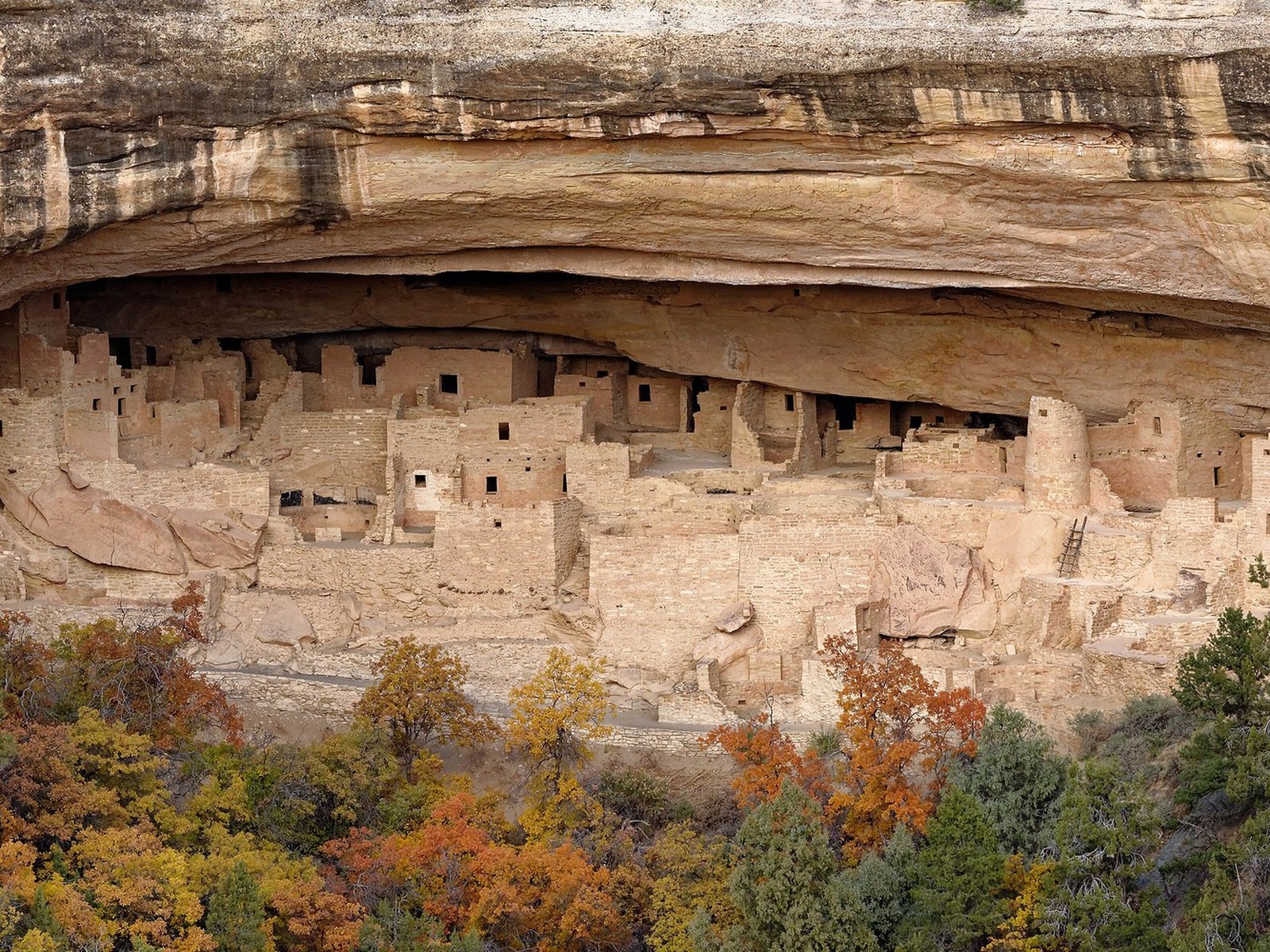
Cliff Palace at Mesa Verde National Park in Four Corners country

Who This Journey Is For

This journey suits travelers who want to understand the Southwest through people and place as well as scenery, and who are comfortable following the access, photography, and cultural expectations that vary from one community and site to another.

The Respectful Learner: Wants context, humility, and care when traveling through living cultural landscapes and Indigenous homelands.

The Archaeology & History Traveler: Is interested in Pueblo architecture, ancestral settlements, rock art, trade, migration, historic roads, and how interpretation continues to evolve.

The Scenic-Road Traveler: Enjoys the long views and transitions between Sedona, the Painted Desert, Four Corners, San Juan country, canyon country, and the Mogollon Rim.

The Photographer: Values desert light, architecture, canyon form, and landscape—but understands that photography rules vary by site and community.

The Short-Walk Wanderer: Enjoys overlooks, paved or moderate trails, museum stops, and shorter archaeological walks, with longer hikes available by choice.

The Patient Traveler: Understands that local guidance, road conditions, closures, ceremonies, permits, and weather can change what is appropriate on a particular day.
What It Feels Like

The route moves through very different expressions of the Colorado Plateau: red-rock valleys, open desert, sandstone mesas, canyon country, high-elevation forests, ancestral architecture, historic trading landscapes, and broad Painted Desert horizons.

Some places are interpreted through National Park Service sites; others are on or near Tribal lands where local rules, community calendars, guides, and photography requirements matter. The best experience comes from arriving informed and willing to listen.

Expect long views, strong sun, cool high-desert mornings, occasional rough or remote access roads, and days where a museum, overlook, guided experience, or conversation can matter as much as another scenic stop.

Places Worth Exploring

These places help define the Phoenix–Four Corners loop. Before departure, we confirm road and weather conditions, park and Tribal access, reservations, local guidance requirements, photography rules, seasonal closures, and the timing that lets each place be approached with care.

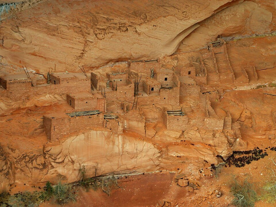
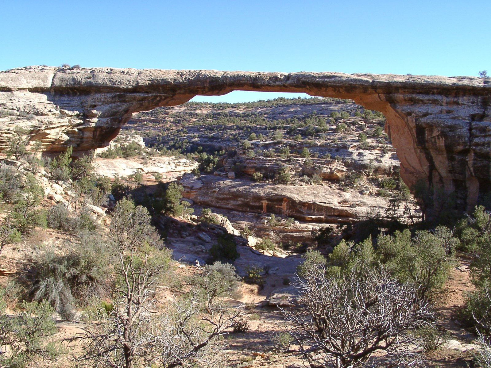
Wupatki & Northern Arizona PueblosWupatki preserves a major ancestral Pueblo community and introduces the route’s themes of trade, adaptation, architecture, and continuing connections to contemporary Pueblo communities.Kayenta & Monument Valley CountryThe Kayenta corridor enters Navajo Nation landscapes where Tribal Park rules, designated routes, local businesses, and current access guidance shape how the area is experienced.Betatakin cliff dwellings at Navajo National MonumentNavajo National MonumentBetatakin and the surrounding canyon landscape offer a powerful view into ancestral Pueblo history in a place whose cultural connections continue today.Owachomo Bridge at Natural Bridges National MonumentBlanding, Cedar Mesa & Natural BridgesSoutheast Utah adds broad mesa country, archaeology, geology, and optional stops such as Natural Bridges when they fit the route, season, and access conditions.Cliff Palace at Mesa Verde National ParkMesa VerdeMesa Verde protects cliff dwellings and mesa-top communities connected to the cultural heritage of 27 associated Pueblos and Tribes.Chaco CultureChaco preserves monumental architecture in a landscape that remains sacred and deeply significant to many Indigenous peoples throughout the Southwest.Hubbell Trading Post & GanadoHubbell remains an operating trading post on the Navajo Nation and offers a grounded look at trade, weaving, art, livestock, and the long history of exchange in the region.Canyon de ChellyCanyon de Chelly is home to Diné families and combines rim overlooks, ancestral places, farms, living community, and canyon experiences available with Navajo guides.Petrified Forest & Puerco PuebloPetrified Forest combines Painted Desert scenery, petrified wood, ancestral Pueblo sites, petroglyphs, and the historic Route 66 corridor on the return toward central Arizona.San Juan River at Goosenecks State Park UtahSan Juan River CountryNear the Four Corners portion of the route, the San Juan River cuts through open plateau country and can support an additional scenic stop when timing makes sense.
Stories & Possibilities

Some experiences belong naturally on the loop; others deserve more time or require special planning. We add them only when current access, local rules, road conditions, guides, weather, and your interests support the choice.

Living Communities, Not a Frozen PastThe route is strongest when interpretation connects ancestral places with living Pueblo, Diné, and other Indigenous communities rather than presenting Native history as something that ended centuries ago.
A Navajo-Guided Canyon ExperienceAt Canyon de Chelly, a registered Navajo-guided canyon tour can add local knowledge and access beyond the rim drives when availability, conditions, and your interests align.
Mesa Verde Beyond the OverlooksMore time can support a ranger-led cliff-dwelling tour or a slower museum and mesa-top day when reservations and seasonal availability make it possible.
Chaco With Enough TimeChaco rewards an unhurried visit because the drive, road conditions, great houses, landscape, and interpretive context make it more than a quick roadside stop.
Trading Routes & HubbellHubbell Trading Post can add a human-scale story of exchange, weaving, art, ranching, and commerce between larger archaeological and scenic landscapes.
Natural Bridges & Cedar MesaAn additional southeast Utah day can make room for Natural Bridges or other public-land landscapes without compressing Mesa Verde or the Four Corners progression.
Petrified Forest, Puerco Pueblo & Route 66The return toward Phoenix can combine geology and cultural history through Painted Desert viewpoints, Puerco Pueblo, petroglyphs, and a surviving Route 66 alignment.
Photography With RespectPhotography can be an important part of this journey, but permissions and restrictions vary. We follow the rules of each park, Tribal site, community, museum, and guided experience.

Journey Style

This is a Four Corners cultural-landscape road journey that balances scenic driving with archaeology, living communities, museum and trading-post context, canyon country, short walks, and time to understand why access and interpretation differ from place to place.

PaceModerate, with time to slow down at culturally significant placesWalkingLight to moderate; longer hikes available by choiceSceneryMesas, high desert, canyon country, volcanic and sandstone landscapesLearningIndigenous homelands, ancestral places, living communities, trade, archaeology, stewardshipNight SkyStrong potential in remote plateau country when conditions cooperateLodgingComfortable hotels in well-located regional communitiesRoute12 days • approximately 1,325 miles • Phoenix loop

Journey pacing: Twelve days gives the Four Corners progression enough breathing room for major cultural landscapes, scenic drives, and regional transitions without making the journey feel rushed. Longer archaeological visits, guided canyon experiences, or added public-land stops remain choices rather than requirements.

People & Place

This route crosses ancestral and contemporary Indigenous homelands across Arizona, Utah, Colorado, and New Mexico. The strongest interpretation recognizes living communities, sovereignty, descendant relationships, local knowledge, and stewardship alongside archaeology and scenery.

Ancestral Places & Living DescendantsWupatki, Mesa Verde, Chaco, Navajo National Monument, Canyon de Chelly, and other sites preserve places connected to living descendants. The story continues through present-day Pueblo, Diné, and other Indigenous communities.
Navajo Nation & Local GuidanceThe route spends meaningful time on and near the Navajo Nation. Tribal Park rules, local guides, businesses, community calendars, daylight-saving practices, and road conditions can all affect how a day is experienced.
Trade, Travel & StewardshipHistoric trade routes, Hubbell Trading Post, modern highways, park stewardship, water, ranching, tourism, and protection of cultural resources all help explain how people continue to live with this landscape today.

Could This Be Your Journey?

This journey may be a good fit if you want a culturally attentive Four Corners loop with archaeology, living communities, mesa and canyon scenery, trading-route history, photography, and enough flexibility to respect local access and pacing.

Lodging: Comfortable hotels in well-located regional communities, chosen to support an unhurried pace.

I’m Ready to Plan This Journey →

Photo Credits & Sources: View credits and sources.